THE STRUGGLE for Western colonial supremacy in Asia began between Portugal and Spain during the 16th century, with the later participation by Holland, Great Britain, Germany and France, all maritime powers of the period, and continued until the early 20th century. Russia and the US, the latecomers, joined the colonial fray in the mid-19th century.
Western presence in Asia was first felt with the arrival of the Europeans in the early part of the 16th century. The sub-sequent establishment of a permanent Western foothold in Malacca became a turning point in Asian history. In particular, it ushered in a new era for the mainland and islands South-East Asia.
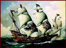
As part of the Spanish exploration of the Pacific, in 1605, more than 15 years after English explorer and privateer, Thomas Cavendish, attack on the Philippines and captured a 600 ton sailing ship, the Manila Galleon Santa Ana manned by 200 men, an expedition of two ships and a launch, commanded by Pedro Fernandez de Quiros, was fitted and sailed from the coast of Peru to explore the Western Pacific area.
Describing how de Quiros sighted Australia, then regarded by Dutch explorers as New Holland in most of the 17th century, Patrick Francis Cardinal – Moran, the Archbishop of Sydney, wrote in his History of the Catholic Church in Australasia published in 1895 and said:
‘On the Feast of Pentecost, 1606, he [Quiros] saluted from afar what appeared to him to be the great Southern Continent of which he was in search, and he gave it, in honour of the festival which was that day celebrated, the name ‘Tierra Austral del Espiritu Santo,’ which has been justly translated ‘Australia of the Holy Ghost.’’
This expedition provides an early link between Australia and the Philippines. De Quiros was the captain and chief pilot of the Alvaro de Mendaña expedition that earlier twice-explored the Pacific in 1567 and 1595. Mendaña, nephew of the Viceroy of Peru, explored the area west of the South Pacific looking for the legendary wealth of the famous biblical King Solomon and attempted the ‘discovery of the southern terra firma. Mendaña discovered some islands in the Pacific instead, naming them the Marquesas and Santa Maria islands.
It was Mendaña who first discovered ‘the middle [passage] of those great islands located from thirteen to fourteen degrees south latitude’
which authorities believe to be the present Torres Straits. It was also during this voyage that Mendaña discovered the Solomon Islands. The Spanish explorer’s plan to establish a Spanish colony in the Pacific failed because of sickness and death among the members of his company, the future colonialists, not to mention the hostilities shown by the islanders.
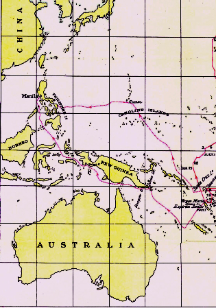
The Spanish settlement only lasted 25 days. Most of the settlers became ill from eating poisonous fish and more than a week later abandoned the settlement. De Quiros then decided to sail back across the Pacific to Mexico by way of California. Luis Vaez de Torres, de Quiros’ second-in-command, decided to sail north towards Manila through the difficult, narrow, and dangerous strait which earlier, in 1595, Mendaña referred to as the ‘middle’ passage. It is significant to note that it was a Scot, Alexander Dalrymple who, in 1767, published a chart of New Guinea identifying the southern coast running west of the Solomon Islands as ‘Torres’ and now popularly known as Torres Strait.
Arriving in Manila in 1607, Torres prepared his report on the discoveries of de Quiros and clearly described his perilous journey through a ‘channel’ with a reef of ‘many shoals and great currents’. He also talked of ‘very large island’ and the appearance of ‘more [islands] to the southward’ which are now known to be those near Cape York Peninsula.
In an undated memorial addressed to King Philip III of Spain, Don Juan Luis Arias discussed the subject of exploration and colonisation of parts of Australia that fell within the Spanish sphere or jurisdiction under a Papal grant. The areas covered consisted of the New Hebrides and half of the continent of Australia, excluding Western Australia and Tasmania. This document also described the Torres voyage: ‘… he [Torres] sailed westwards, having constantly on the right hand the coast of another very great land (emphasis mine), which he continued coasting, according to his own reckoning, more than six hundred leagues, having it still to the right hand…’
The de Quiros and Torres expedition ended the period of Spanish exploration of the Pacific. Another expedition was fitted out under the command of de Quiros in search of the Great Australian continent, but he died in Panama before he could sail further into the Southern Hemisphere. Australia was not destined to become part of the Spanish empire.
Many years later, during the 1760s, an English expedition to the Pacific under Commodore John Byron explored the southern continent. Meanwhile, the Torres’ account, the earliest link between the Philippines and Australia, was gathering dust in the Spanish archives in Manila. Succeeding English explorations took place, including the first voyage of Captain James Cook who reached Tahiti in 1769 and eventually ‘discovered’ Australia.
It was only during the English occupation of Manila between October 1762 and May 1764 more than 100 years later that the Torres documents were discovered.
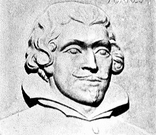
Little is known about Luis Vaez de Torres. What is known is that he was the first European to visit this outpost of the British Empire. As a Spanish navigator, in August 1606 and without a chart, he threaded his way through the strait now bearing his name.
In his report, prepared in Manila, to his King, he said: ‘All this land of New Guinea, people with Indians; all along the coast are many islands and habitations. Without [outside] these islands there runs a reef of shoals and between them [the shoal] and the mainland are the islands. There is a channel within. In these ports, I took possession for your Majesty. Here were very large island and there appeared more to the southward.’
Commenting on this voyage of Torres, George Collingridge stated in his book Discovery of Australia and New Guinea published in 1906: ‘Torres sails towards Australia from the New Hebrides, passes through the straits that bear his name, and discovers Australia, without, apparently, being aware of the fact.’
In his book New Found Lands: Maps in the History of Explorations, Peter Whitefield described the event: ‘Reaching the extreme eastern capes of New Guinea, Torres recorded that ‘I could not weather the east point, so I coasted along the westward on the south side’, from where he sailed on through the Moluccas. Torres had in fact made a remarkable passage of the strait which now bears his name, littered with dangerous reefs and with the continent of Australia on his port bow.’
Many historians are amazed that even without a chart, Torres leaves it to his imagination which of the channels he passed through. Dalrymple gave him the credit of their discovery, and fixed his name to the straits – now known as Torres Straits.
Many years later, during the Seven Years War in Europe that started in 1756, the report made
in Manila by Luis Vaez de Torres describing how he navigated the treacherous strait which became known in Australian history as Torres Strait would resurfaced. The Torres’ report to the Spanish Monarch also described the location and the perilous travel through a ‘middle passage’ to Manila after the de Quiros expedition ended.